April 5, 2021
Source Waters – A Spotlight on the Red Deer River Watershed
submitted by the Red Deer River Watershed Association
RDRWA’s New Film “Source Waters” Shines Spotlight on the Red Deer River Watershed to inspire and inform water and land planning and management.
Where does our water come from? How much do we have? How do we communicate about land and water issues more effectively?
Water connects us all, from the braided waters near Sundre to the starkly beautiful and dry Badlands. From the suburbs of Red Deer to the dusty main street of Rowley, no matter where you live, the RDRWA hopes that Source Waters: The Rivers That Shape Us will inspire new conversations about water. This will give our municipal decision-makers and communities a better sense of where our water comes from, how much we have, and the key challenges and opportunities moving forward.
In a new documentary film project led by the Red Deer River Watershed Alliance (RDRWA), we aim to answer these questions, raise awareness about the Red Deer River watershed, and highlight water and land issues in central Alberta.
Source Waters: The Rivers That Shape Us was filmed in late 2020, and provides essential context for people wanting to learn more about the landscapes, communities, and waters of the Red Deer River watershed. Starting in the mountainous headwaters of the Red Deer River in Banff National Park, the documentary takes viewers on a journey eastward across the watershed, through communities including Sundre and Red Deer, and east to the Special Areas just shy of the Saskatchewan border. Along the way, the RDRWA talks to scientists, elected officials, ranchers, land-owners, and agricultural producers about the “big picture,” of the watershed, and to learn more about what issues are most important to them.
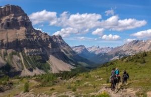
Ascending Deception Pass, Banff National Park.
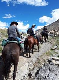
RDRWA film crew en route to the Skoki Valley, Banff National Park
A Watershed-Scale Approach
The Red Deer River watershed is vast, part of the larger South Saskatchewan River Basin (SSRB), and is the only sub-basin in the SSRB still open to new surface water allocations. It covers an area of 49,650 km2, and is home to over 300,000 people and 54 urban municipalities, including the cities of Red Deer and Brooks. The watershed also includes 20 specialized municipalities, over 13,000 farms, and a diverse range of industries. Maintaining and improving watershed health across this busy landscape requires everyone to play their part, but many areas are facing a convergence of growth pressures and water management issues. As various sectors and communities grapple with growth in the context of limited water supplies, the Red Deer River watershed is increasingly a key topic of conversation.
Land-use patterns in the basin are also changing, with approximately 62% of the basin’s land base covered by human footprint — visible alteration or conversion of native ecosystems to residential, recreational, agricultural, or industrial landscapes. In a 2014 study by the Alberta Land Institute, they found that within the Edmonton-Calgary corridor area, urban areas increased by 1600 km2 between 1984 and 2013, and agricultural farmland in the region has become increasingly fragmented. These changes in land use can affect key water quality and water quantity outcomes at the heart of watershed management.
The Red Deer River basin’s status as a water-constrained basin, coupled with increasing growth in various sectors and changing land-use patterns, requires a thoughtful and coordinated approach to watershed management. As one of 11 provincial Watershed Planning and Advisory Councils, a key role of the RDRWA is to act as a multi-sector forum, providing people and organizations with the knowledge and tools they require to make well-informed decisions regarding land and water issues in central Alberta.
Municipalities are key partners in watershed management, yet face a growing set of challenges. Many municipalities in the Red Deer River watershed have experienced flood and drought events in recent years, and many areas in the basin are considered at high risk for future events. For municipalities, a changing climate and increasing hydrological variability can pose challenges to the provision of core municipal services, especially at a time when many municipalities face a fiscal crunch. The RDRWA has listened to the concerns of our partner municipalities, and we are working together to find ways to balance the need for effective planning and conservation in tandem with growth and development.
To move the dial on protecting local communities in the face of these challenges, the RDRWA recognizes we need to do a better job of reaching municipal decision-makers, homeowners, and community members and supporting the everyday conversations and decisions that take place related to water and land use – whether it is a farmer protecting a wetland, a citizen taking a shorter shower, or a municipality investing in green infrastructure. Everyone has a role to play in watershed management – but somehow many of us are still disconnected from the role we play in the bigger system.
A comprehensive assessment of water literacy conducted by the Alberta Water Council in 2016 found that low water literacy is a risk that may result in a disengaged public who is unaware of patterns of water availability and quality and how this may influence their lives. The RDRWA believes that part of the reason for this disengagement stems back to how we frame key water issues, especially with respect to values and messaging and how we reach out to audiences in an increasingly fast-paced media environment. We know that stories have power. Research suggests that audiences find stories and narratives easier to understand and more engaging than traditional logical-scientific communication. While scientific facts are important, we know that facts themselves do not motivate concern or action. Recognizing that many people find water a complex topic to understand and engage with, the RDRWA decided to try a more accessible approach to communicating about water in order to help people connect with watershed issues.
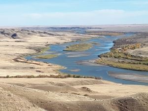
The Red Deer River near Empress, Alberta.
By Land, By Water, By Horse
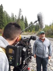
When the RDRWA started planning to film Source Waters in 2020, we expected there would be a learning curve and some challenges along the way. But we had no idea that we would have to adapt to filming a documentary in the midst of a global pandemic! Armed with a COVID-19 filming plan, our weight in hand sanitizer, and a healthy dose of flexibility and good humour, we set out with our intrepid director, Eric Gonzalez, and film crew to visit gems across the watershed.
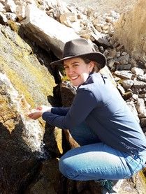
To do justice to the story of the Red Deer River watershed, we knew we had to start at the source. The true headwaters of the Red Deer River are a place few people have visited. Water in the Red Deer River watershed originates in the Skoki Valley of Banff National Park, before travelling downstream through communities including Sundre, Red Deer, and Drumheller. The RDRWA and our film crew travelled to the remote headwaters of the Red Deer River in Banff National Park in late August, traversing rugged terrain on horseback to reach Red Deer Lakes and faraway Oyster Lake. After riding, hiking, and scrambling with cameras, microphones, and other assorted equipment, we finally crested the summit of Oyster Peak and reached the tranquil turquoise waters of its namesake lake. For RDRWA staff Josée Méthot and Rosemarie Ferjuc, it was a true “watershed moment”, watching some of the crystal clear source waters of the Red Deer River emerge from the rock. It was amazing to think about the connectivity of our water cycle; drops of water spilling from a wall of rock eventually wind across Alberta and Saskatchewan, hydrating the prairies en route to Hudson Bay.
Despite the bumps of bushwhacking, it was an indelible experience for all involved, and veteran outfitter Paul Peyto of Timberline Tours reflected that “Oyster Lake has not changed a bit since the last time I was there in 1967.”
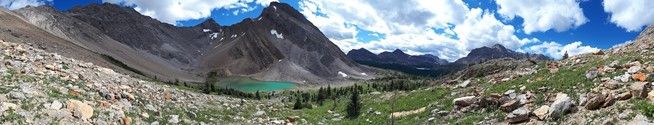
Oyster Lake, near the headwaters of the Red Deer River.
In subsequent weeks, the film crew followed the course of the Red Deer River, stopping in the communities of Sundre, Red Deer, Starland County, and Special Areas, and travelling by car, truck, quad, canoe, ferry, and on foot to reach some of the most unique landscapes of the watershed. We are grateful to everyone we met along the way who helped answer our questions, helped us way-find when we were lost, and most importantly, helped us get to the heart of the stories that embody the spirit of the people and places of the Red Deer River watershed.
RDRWA’s Josée Méthot at the source of the Red Deer River.
Dr. John Pomeroy, Director of the Global Water Futures Program told the RDRWA, “There will be tremendous challenges moving forward, but we have a great tradition in western Canada of finding solutions.”
Want to learn more? The Red Deer River Watershed Alliance had a virtual launch of “Source Waters: The Rivers That Shape Us”on World Water Day, March 22, 2021. We will be sharing updates about the film launch via our monthly e-newsletter and on social media over the coming weeks. Be sure to visit www.rdrwa.ca for more information, and follow us on Twitter (@RDRWA) and Facebook (www.facebook.com/rdrwa) to stay connected.
The Red Deer River Watershed Alliance is thankful to have this project supported through funding from the Alberta Real Estate Foundation. AREF’s support has been instrumental in helping the RDRWA bring the Stories of the Watershed to life, and realise the vision for this project.
Topic
Similar News